
 NWA October 2018 Newsletter What's in this newsletter...
Voting for Autumn
Ahhh, autumn. Take a deep breath and take it all in. Depending upon where you are, you might still have dew points in the middle 70s with your focus on an easterly wave, or you might have started your day admiring frost on dry leaves in hues of orange, yellow or red. Hopefully you are not still inhaling smoke from distant wildfires. As we prepare for the change of seasons, the National Weather Association prepares for a change in bylaws. Bylaws guide us in “Connecting Operational Meteorologists in Pursuit of Excellence in Weather Forecasting, Communication and Service.” The time to provide comments has ended, but you can still look at the existing and proposed bylaws, a two-page information sheet highlighting the proposed changes, and the proposed Certificate of Incorporation on the NWA website. NWA members have until October 25 to vote on the proposed bylaw changes and the new Certificate of Incorporation by paper ballot or online. Have you voted yet? Heading toward winter, get ready to vote again. Ballots come out in early November for you to select your NWA leadership. Unlike for tomorrow’s weather, you do have a voice in how NWA changes or remains the same. Let’s keep on diversifying our membership and leadership with multiple talented, eager and passionate people to propel us forward. While our annual meeting in Saint Louis was a big deal, it is not the end of my term and it doesn’t end the many projects before your Officers and Council. I pledge a cloud in every neighborhood; a breeze in every hamlet; and a raindrop in every rain gauge. Ask not what NWA can do for you but what you can do for NWA. For NWA, you can vote. An update on Multiple-Radar/Multiple Sensor (MRMS) Hello from the NWA Remote Sensing Committee! When meteorologists think of remote sensors, we think of weather detection using instruments such as radar, satellite, and lightning location sensors as individual sources of information. But what if we could view a weather event from multiple “eyes” to give a more accurate picture of what is happening, and view the event from different angles? This is precisely the concept of the Multiple-Radar/Multiple-Sensor (MRMS) system developed by scientists at the National Severe Storms Laboratory (NSSL) being used operationally by the National Weather Service (NWS). The MRMS system starts by combining data from an entire network of radars into a rapidly-updating “cube” of information with an update rate of 2 minutes and grid resolution of 1 kilometer. Next, other remotely sensed and in situ data are integrated into the cube, including satellite, lightning, rainfall, surface observations, and upper air data. These data are fused to create a number of products designed to help in making warning decisions for wind, hail, tornadoes, lightning and rainfall for the public, first responders, aviation, and other users. To highlight a few examples, reflectivities from multiple radars are combined with thermodynamic profiles to diagnose hail size (see figure). Hail size combined with satellite and other near-storm environment data can be used to diagnose the probability of severe weather (ProbSevere) within storm clusters detected in the MRMS cube. The MRMS system also produces a number of quantitative precipitation estimates (QPE) that are more accurate than their single radar counterparts. And MRMS data are ingested into the High Resolution Rapid Refresh numerical model analyses to improve precipitation and convection forecasts. The MRMS data has been available to NWS forecasters, aviation meteorologists, weather companies, and private users (via GRearth and other platforms) for several years via the NOAAPort Satellite Broadcast Network. The next version of MRMS (v12) is expected to become operational sometime in early 2019. New products available in v12 include an improved algorithm for the 0-30 minute cloud-to-ground lightning probability product and a new 0-60 minute product, replacement of the QPE “gauge-corrected” and “mountain-mapper” products with a new multi-sensor QPE that blends dual-polarization radar QPE, rainfall observations, satellite QPE, and numerical model QPFs to provide better QPE in data sparse regions, and MRMS domains outside of continental United States including the Pacific, Alaska, and Caribbean. In addition, new products available on the MRMS operational system to NWS users will include the Cooperative Institute for Meteorological Satellite Studies (CIMSS) ProbSevere product (which was experimental), a QPE accumulation quality index, an improved lightning density product, and several new transportation products. The next version of MRMS will follow v12 by 15-21 months. Plans for the future version include a major design upgrade to improve product latency, accuracy, and resolution. For more information on MRMS, consult the MRMS informational page and the MRMS operational training page, and the MRMS operational product viewer.
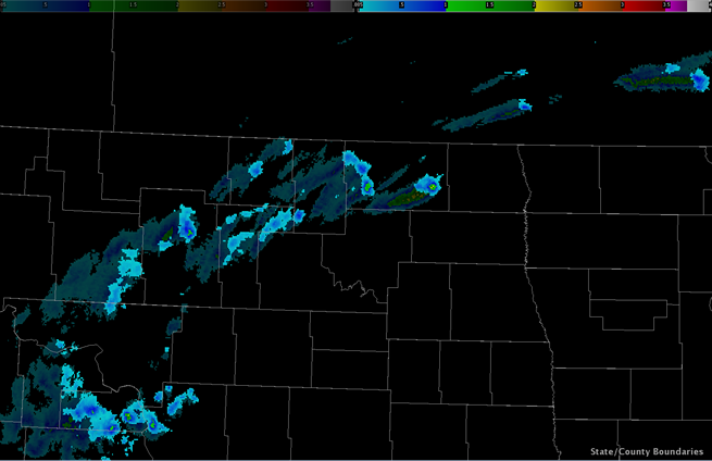
Image combination of instantaneous Maximum Expected Hail Size (MESH; top opaque layer) and 60-minute MESH tracks (underlying translucent layer), otherwise known as MESH “meteor trails”, associated with an MCS over North Dakota and Minnesota at 2210 UTC on July 21, 2014. On Our Radar: Renny Vandewege
What do you do in your current position at WDT? I am the Senior Vice President of Business Development at Weather Decision Technologies in Norman, Oklahoma. My job is to work with a team to identify and bring to life new partnerships and customers where our products and services drive informed weather-related decisions to plan and protect critical business assets. I’ve been fortunate to work with professionals in agriculture, energy, marine, live outdoor events, commodity traders, and data analytics where weather is one of the top drivers of business success. Where did you go to college? I have a Master of Science Degree in Geosciences with emphasis in Meteorology from Mississippi State University. I absolutely loved my time there and feel very thankful for the opportunities that MSU presented me both as a student and afterwards as an instructor at the university. What piqued your interest in meteorology? It started out as an intense fear of tornadoes as a child, and the desire to learn about my fear turned into obsession and passion. The first weather question I wanted to learn as a kid was how an otherwise benign warm and humid spring day could turn into a tornado outbreak. What's the coolest thing you are working on right now? It was extremely rewarding to be part of the team that helped with the Thailand Cave Rescue. A colleague at Google reached out to our CEO, Mike Eilts, about our willingness to provide forecasts and data to the rescue teams in Thailand and our team’s fast response and quality data helped get the kids and coach out quickly and safely. What is one aspect of your job or career that was unexpected? I never expected to experience all the amazing places weather has taken me in my career. From storm chasing near the Canadian and Mexican borders to working on partnerships with small startups and Fortune 500 companies in places like Israel, Brazil, Australia, and England, weather has allowed me to experience people, places, and cultures I never realized. What do you see as the biggest challenge facing meteorologists today? Communication of forecast and threat information will always be a hot topic and challenge. It is hard enough with one medium of communication, but given today’s thousands of avenues to receive a weather forecast, it will be critical that meteorologists learn and improve constantly on the best way to reach and communicate with those that don’t understand meteorology. What is the best piece of advice you've been given? Always push yourself to be a little uncomfortable at what you are doing in your career and you’ll always keep growing. What is the one piece of advice you would give to a student pursuing a degree in meteorology or a related field? I have two pieces of advice I share with all students: 1) It is very important to learn a secondary knowledge base to go along with your meteorology knowledge. That may be GIS, communication, data science, computer programming, statistics, etc. This extra tool is probably the difference in you finding a job or not; and 2) pull your head away from your phone or computer and observe the weather around you. Feel what it is like to have an outflow boundary come through, notice the subtle changes in cloud types before a front comes through. The observation of the weather around you makes using the tools in your toolbox that much more valuable and your prediction skills improve even more. Who inspires you? My father (some say we are like Tommy Boy and Big Tom Callahan). How do you recharge? I like to disconnect from my phone and play a round of golf or fish for a few hours, which it turns out are both weather sensitive activities! I love sports and outdoor cooking. I’m worthless in a kitchen but give me a grill or smoker and I can make the magic happen. And I love trying new restaurants and traveling with my wife. New IBHS CEO to Keynote at NDRC18
Roy Wright joined IBHS in 2018 with more than 20 years of experience in insurance, risk management, mitigation, and resilience planning. Convinced that the continuing cycle of human suffering that strikes families and communities in the wake of severe weather can be broken, Roy leads a team of scientists and risk communicators who deliver strategies to build safer and stronger homes and businesses. IBHS’ real-world impact enables the insurance industry and affected property owners to prevent avoidable losses. Previously Roy served as the Chief Executive of the National Flood Insurance Program and led the Federal Insurance and Mitigation Administration of FEMA, where he directed the resilience programs addressing earthquake, fire, flood, and wind risks. In these roles, he guided several programs that promote a risk-conscious culture, enable faster disaster recovery, and address long-term vulnerabilities to life, property, and well-being in communities across the United States. This year’s lineup of presenters also includes Kenneth Graham, National Hurricane Center Director; Leslie Chapman-Henderson, FLASH President and CEO, National Weatherperson of the Year Ada Monzón, Meteorologist, CBM - WIPR-TV; Lt. Col. Kaitlyn Woods, Hurricane Hunter - Chief Meteorologist, 53rd Weather Reconnaissance Squadron, USAF and many more. NDRC18 attendees will hear from BASF Corporation, FEMA, Florida International University, Insurance Institute for Business and Home Safety, International Code Council, James Cook University of Australia, Lightning Protection Institute, MIT, NOAA, Portland Cement Association, Southern California Earthquake Center, Smart Home America, State Farm, The Weather Channel, University of Florida, University of Notre Dame, USAA, and Verisk. Click here for the full lineup. NDRC18 is proud announce that the International Code Council (ICC) is serving as the Titanium Sponsor and sponsorship opportunities are still available. When you sponsor, you will join ICC as well as Gold Sponsors BASF Corporation and USAA, Silver Sponsors, ISO, National Wildlife Federation, and Portland Cement Association, Bronze Sponsors National Flood Barrier Testing & Certification and Smart Vent, and General Sponsor Comfort Block and Enterprise Community Partners. NDRC18 will be presented by the FLASH Partnership and “Presenting Partners”, including the American Meteorological Society, Association of State Floodplain Managers, Central United States Earthquake Consortium, National Fire Protection Association, National Storm Shelter Association, National Weather Association, and Southern California Earthquake Center. For more information about the NDRC18, email [email protected]. You may click here to secure early bird registration, explore sponsorship opportunities, see the full agenda, and learn more. Student Presentation Winners at the NWA 2018 Annual Meeting Oral Presentation Winner: Undergraduate Poster Winners: 2nd: A Statistical Approach for Defining Speed Thresholds for Upper Jet Streaks 3rd: Case Study of a Tornado Event in Indiana and Ohio on 19 April 2011 Graduate Student Poster Winners: 2nd: Analog-Based Severe Probability Guidance 3rd: ENSO and PDO related Variability in South Pacific Circulation Patterns and Seasonal Range Prediction for the Altiplano Region of Bolivia in South America
Tom Skilling recently celebrated 40 years at WGN in Chicago. Congratulations, Tom, for serving the Chicago area with your accurate and enthusiastic forecasts! Read more about it, and watch WGN's tribute to Tom, on WGN's website. Diversity University: Weather Support in 1492 Every October brings the ongoing debate about celebrating Columbus Day or Indigenous Peoples' Day. Nonetheless, weather savvy individuals may start thinking about some "what if" weather situations that could have occurred on Columbus' first voyage across the Atlantic. Columbus set sail with ships that had a new, light-weight design that was a bit faster in the open ocean: a whopping 4 knots on average. It makes sense why it took two months to cross the Atlantic. Columbus left Portugal and restocked in the Canary Islands before heading west across the Atlantic in August of 1492, near the peak of hurricane season. It’s hard to say what would have happened had they encountered a major hurricane on that first voyage. Navigation had only advanced to the use of a magnetic compass at the time, and that probably would not have helped much had they encountered significant weather while under sail. Weather has fascinated the human race since the beginning of time. Weather folklore and superstitions continue to this day among many cultures and individuals despite long-range climatological modeling and science to back up our forecasts. Some people place bets on how harsh the upcoming winter will be based on how big the brown area is on a woolly bear caterpillar, and do the same for the end of winter based on whether or not a groundhog sees its shadow (festivals are held for both animals in several states). Back in the early 1950s, U.S. Senator Robert Kerr was interested in seeing how well Native Americans could forecast the upcoming winter. It had been observed that several Native American tribes in Oklahoma and Desert Southwest made forecasts that, at times, accurately predicted winter weather. The AMS journal Weather, Climate, and Society has an interesting article on this study, which includes responses from the tribal leaders who were contacted. Chances are the indigenous people of Cuba and Haiti also made observations that helped them predict the weather in the 1400s. Perhaps they helped Columbus and his fleet choose a safer route heading east to Portugal. Perhaps it was their understanding of prevailing winds during certain times of the year as well as ocean currents that helped Columbus and his fleet make it back safely. We'll never know, but what an amazing example of collaboration and mutual respect that would have been! References en.wikipedia.org/wiki/Indigenous_Peoples%27_Day New Publication in the Journal of Operational Meteorology
JOM 2018 -7 (Article): Impacts of a University-led, On-demand Sounding Program on Human and Numerical Weather Prediction Model Forecasts in an Upper-air Observation Hole, by Benoit, M. D., C. J. Nowotarski, D. T. Conlee, and L. Wood. The JOM publishes submissions in four categories: Article, Short Contribution, Images of Note and Commentary. The JOM is a peer-reviewed, all-electronic journal with an international scope, providing authors with the benefits of economical publication costs and rapid publication following acceptance. If you are interested in submitting a paper to the JOM, please go to the website for author information. Thank you to the JOM authors, reviewers and editors for continuing to make JOM a success! |
 The Membership & Marketing Committee recently sat down with Renny Vandewege of Weather Decision Technologies (WDT). Renny has been an active NWA member since 2004 when he joined as a student at Mississippi State University. His fascinating career has taken him from local television to teaching future meteorology students, and now working in industry where he assists businesses in making weather-related decisions. Renny shared with us how a fear of tornadoes as a kid growing up in Lincoln, Nebraska, led to a professional career in the weather industry. He also discusses challenges facing meteorologists today and offers advice to individuals who desire to pursue a successful career in the weather enterprise.
 Roy E. Wright, President and Chief Executive Officer of the Insurance Institute for Business & Home Safety (IBHS) will be a featured keynote speaker at the
  One new article has been published in the NWA’s JOM in the last month.
Announcements

Are you WeatherReady? NWS weather preparedness information.
The NWA is proud to be a Weather-Ready Nation Ambassador™.
*********
For assistance, please contact:
[email protected]
405-701-5167