|
What's in this newsletter...
- President's Message
- Rare “Snownado” Captured in Northwest New Mexico
-
44th NWA Annual Meeting Update
- Important Dates
- New Members
- #SafePlaceSelfie Day on April 3
- NWA Staff Changes
Important Dates
44th Annual Northeastern Storm Conference
March 8-10
Southeast Severe Storms Symposium XVII
March 23-24
Ohio Severe Weather Symposium
March 28
23rd Severe Storms and Doppler Radar Conference
March 28-30
NWA 44th Annual Meeting
September 7-12
See other events and stay up to date on your
professional development
New Members
NWA has welcomed nine new members since our last newsletter was published.
Do you know someone who you think would love to join the NWA? Forward them this newsletter to give them a sample of all we have to offer.
Click here to join!

#SafePlaceSelfie Day on April 3
By Doug Hilderbrand
If you could pick one extreme weather preparedness action for everyone in the country to do, what would it be?
The NWA Social Media Committee and a team from the National Weather Service argue that answer is knowing your safe place location during all natural hazards.

Wouldn’t it be amazing if we could remove the “wrong place at the wrong time” explanation for why tragedy occurs during tornadoes, floods, heat waves, rip currents, tsunamis, and all other threats? Practicing what to do should a hazard strike makes the action second nature when time is of the essence. That is why we’re encouraging all NWA members to help promote and participate in the #SafePlaceSelfie Day on April 3. What can you do to help?
- Post a selfie of your safe place location at 11:11 a.m. local time on April 3
- Promote the event and encourage others to participate by challenging them on social media platforms
- Create friendly competitions within your TV market or within your organization
- Go beyond safe locations for tornadoes (e.g., your bathroom tub) and get creative with other hazards in mind (e.g., a lifeguard stand at the beach, a lightning-protected shelter, or an ice cream shop on a hot day)
Together, we can reach millions across the country and lead them to take that No. 1 preparedness action and do their part to help build a Weather-Ready Nation.
Return to top
NWA Staff Changes
Member Services Specialist Tanya Schoor has moved on to a new chapter and left the NWA in February. Tanya and her husband Greg recently welcomed their son, Jack, to the family.
Tanya served NWA members for just over two years. We appreciate all she did to add improvements to our member services. She was instrumental in getting Member Connect up and running, kept our web page fresh and spent most of her time assisting those in the Seal program or welcoming new members. She was also very involved in assisting the NWA Foundation with scholarships, grants and other tasks.
She is missed at the NWA office, but we know she is enjoying her time with Jack. We wish Tanya, Greg and Jack all the best!
Bryce McElhaney joined the NWA Office team in late February as the Communications and Marketing Coordinator.

He has a degree in Journalism from Gaylord College of Journalism and Mass Communications at the University of Oklahoma. Bryce was formerly employed by The Oklahoman/NewsOK and managed content on NewsOK.com and the social media accounts. He has worked extensively in content management, social media marketing and engagement through his work as an online editor for the New Territory magazine, and by assisting a non-profit in video production.
Bryce is jumping in and quickly learning our systems, working with several committees, and beginning work on new ideas for promoting the NWA and our services. Welcome Bryce!
The National Weather Association Foundation offers scholarships for college students and grants for K-12 teachers. It is a 501(c)(3) non-profit, separate from the NWA. Contributions and gifts to the Foundation are deductible as charitable donations.
EIN: 81-4218870
Return to top
|
|
Annual Meeting Abstract Idea?
Paul Schlatter, NWA President
You still have time…the deadline to submit an abstract for the NWA Annual Meeting in Huntsville, Alabama, is March 7. Recall from the February newsletter that the Annual Meeting Steering Committee, which leads the process to accept talks and posters and assign them to sessions, is looking for abstracts that are interactive, jointly presented, and tie into this year's theme of “Pay it Forward.” You also have the option to recommend a session or special event. Whatever you do, make plans to attend and finish that abstract you keep putting off for tomorrow. There are only a few tomorrows left!
I want to make another plug for the Mentor/Mentee Special Session at the upcoming Annual Meeting. If you ever wanted to pay it forward for someone who was instrumental in your career, this is a fantastic way to do it. We are looking for mentor/mentee pairs to be a part of a panel discussion moderated by yours truly. My goal is to get a discussion going that highlights how you met your mentor, what makes the relationship special, and how it’s mutually beneficial. I truly believe everyone in attendance will benefit from hearing about mentorship from both sides of the coin. Submitting an application is easy: just answer a few simple questions about you and your mentor. The best part is that there is no fee for it, so what do you have to lose? To submit an application, go to the call for abstracts page on the NWA Annual Meeting page and click on the button for “Mentor and Mentee Session Form.”
For the remainder of this month’s message, I wanted to share a story from the forecast desk. I was working an evening shift that started at 1 p.m. on Saturday, Feb. 16. I mention the start time because I used the first and probably most important tool in any forecaster’s toolbox: a visual inspection of the atmosphere! Before looking outside to the west, I had briefed myself on the weather message of the day via the morning Area Forecast Discussion issued by my office (NWS Boulder). Extremely cold air aloft was being advected over the foothills west of Denver and forecast to be over the plains during the afternoon (forecast to be -30 C at 500 mb, and -17 C at 700 mb). At the surface, temperatures had warmed to 40 F by midday with the strong mid-February sun. While numerical models indicated the potential for convective snow showers, they were unable to predict the intensity, timing, and evolution of the activity we saw that day. This is not unusual for model forecasts of this type. In events like this, we take what we can get from numerical weather prediction, but most of the time using observational data is the only way to understand what the atmosphere is about to do.
On my drive into work, I saw convective towers just west of Denver over the mountains. It reminded me of a summer day when convective storms form over the mountains midday and move east over the plains by early afternoon. Only, this was February, and the convective showers were dropping heavy snow in brief bursts. Our conceptual model of convective snow showers forming over the mountains on the leading edge of the cold air aloft and then moving east over Denver was occurring in real-time when I arrived at work. It would be feast or famine—anyone directly under one of those showers would experience 1/4-mile visibility and a quick inch of snow in roughly 20 minutes. It would be over about as quickly as it started. While in the office, we used radar and satellite data to monitor the progression of the convective snow showers. Operational meteorologists are in the business of predicting impacts, so we also utilized webcams from across Denver to see what was going on in the worst of it. The Colorado Department of Transportation has webcams on every interstate in the metropolitan area spaced approximately every mile. We also used Twitter, because citizens across the front range of Colorado love tagging our office (or via broadcast meteorologists retweeting the photos as we follow them) with weather-related photos, videos, and other useful information. As the showers moved across Denver, we found webcams showing the heavy snow and low visibility. We were posting across social media platforms on what to expect: brief near white-out conditions, wet to perhaps slushy conditions, and we urged drivers to slow down. We were sending out radar updates every 30 minutes or so as the showers organized into a line, reiterating that drivers should slow down when they encounter the snow squall.
Some of you may wonder if we issued a snow squall warning. Wait, what’s a snow squall warning? The NWS is experimenting with a new short-fuse warning product called a snow squall warning that is similar to a severe thunderstorm warning but issued when rapidly deteriorating conditions are expected from convective snow showers. The warning is for heavy, short-duration snow that reduces visibility to 1/4 mile or less, contains gusty winds, and/or results in treacherous travel on roads that are expected to quickly ice up either from the intense rate or the cold road temperatures. NWS Boulder is not one of the offices experimenting with these warnings; otherwise we would have issued one given the intense snow and potential for icy roads. By 4 p.m., the snow band continued to the east and approached Peña Blvd, the freeway that connects Denver to Denver International Airport. The band slowed down with intense 40-45 dBZ echoes right over the freeway. Unfortunately, there are no webcams along the route so we weren’t sure how bad it was when Twitter came through for us with a photo of the conditions.
The roads were clearly slushy, snow packed, and likely slick with severe restricted visibility. Winds were not contributing to the lower visibility (10 mph at the time), confirming the sheer amount of snow falling all at once. In about 45 minutes, 2 to 3 inches fell over that stretch of freeway. The low visibility and slick conditions led to a 49 car pileup of people trying to get to the airport. While 17 people were injured, thankfully none of the injuries were serious. It was a sobering moment for our office because up until that point there were no accidents as the heavy band moved across the metropolitan area until the band slowed down over the freeway. I tell this story to illustrate that this event was tailor-made for a snow squall warning. Would a snow squall warning have helped prevent the 49 car pileup? That’s up for discussion, but I think it would be unlikely given the intensity of the snow and desire the drivers had to get to the airport at that time on Saturday afternoon. It only takes one car going too fast for the conditions to cause an accident like that. In the near future (hopefully by next snow season) these new products will be available across the country and, as an enterprise, we’ll need to band together to explain to the public what the warnings mean and what to do when they are issued. Maybe someone from one of the offices that issue these warnings will team up with a broadcast meteorologist or emergency manager to share their experiences at the Annual Meeting? "You are welcome" for that abstract idea!
Return to top
|
|
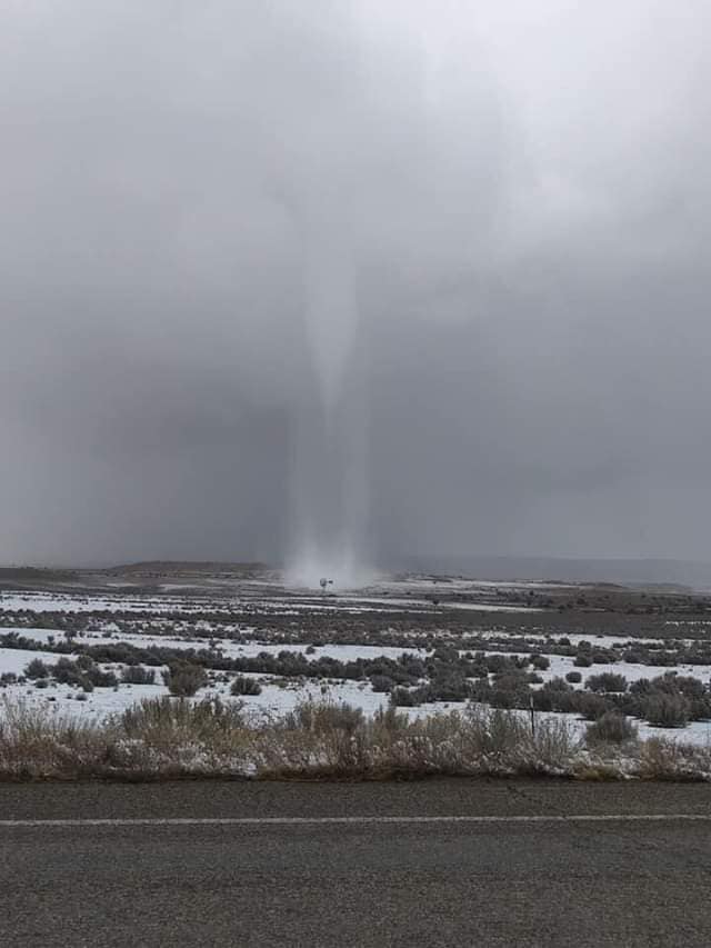
Exceptionally Rare “Snownado” Captured in Northwest New Mexico
Byron Morton, KOAT-TV Meteorologist, Albuquerque, New Mexico and Kerry Jones, Meteorologist in Charge, NWS Albuquerque (ABQ NWS report)
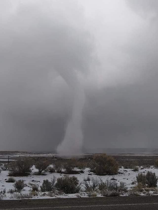
Shocked! How could this be real? These thoughts raced through my head as I stared bug-eyed at the images that were literally jumping off my iPhone screen. Having been a broadcast meteorologist in New Mexico for more than 17 years, I had never expected to see a tornado touching down on a snow-covered, high desert landscape in the middle of winter.
After an exciting weekend of weather, I checked the messages on my professional Facebook page in hopes there would be some good content I could share on social media. It was my lucky day! Right at the top was a message from Lydell Rafael with the words, “Some photos from Tinian, NM just 5 miles west of Torreon, NM…” When I opened the message, I couldn’t believe what I was seeing: photos of a tornado…or a “snownado”! The photos were taken the day before on Sunday Feb. 17, 2019. One photo showed a rope-like condensation funnel reaching from the cloud base all the way to the ground (Figure 1). And in another photo, a defined funnel with a distinct snow-white debris cloud (Figure 2). My meteorological gears started churning. I also wanted to get more eyeballs on the images to help corroborate this very rare phenomenon. So, I tweeted and posted the images to both Facebook and Instagram. Almost instantly, I got a reply on Twitter of images showing Doppler velocities and reflectivity (thanks Stu Ostro), which definitely suggested—albeit weak—some gate-to-gate shear and precipitation near where the photos were taken.
Inspired, I emailed the photos to Albuquerque NWS WFO (ABQ NWS) and asked for their analysis. Meanwhile, I continued my research by first referencing the Tornado History Project website. It was there that I discovered this could be the first tornado on record for New Mexico in the month of February. The man who initially shared the photos, Lydell Rafael, was a Navajo Radio broadcaster and informed me that the event had occurred on the Navajo Reservation near Tinian at approximately 3:22 p.m. Rafael put me in touch with Antonio Chiquito, who had captured the “snownado” on video through a Facebook live stream. Antonio told me over the phone that he was herding sheep and about to go inside to get out of the cold when he looked over his shoulder and saw the funnel. He estimated the tornado was on the ground for approximately seven or eight minutes. Antonio said the tornado cut across a sparsely vegetated area with no structures nearby, as was evidenced by the photos and video, and that he didn’t see any or suspect there was any damage. The team at the ABQ NWS then sent me the images of Doppler velocities and reflectivity they had been analyzing as well, which confirmed some weak rotation and precipitation.
 Kerry Jones, Meteorologist in Charge at ABQ NWS, and his team’s analysis revealed some fascinating insight. They noted that landspout tornadoes, although rare, have been documented in western New Mexico. And, until this year, February was one of two months without a reported tornado in the state. A locally developed database of New Mexico tornadoes by ABQ NWS meteorologist Jennifer Shoemake confirmed this fact. Indeed, snow on the ground made for an exceptionally rare snownado as seen in the photos. Kerry and his team also discovered an interesting side note: that a landspout captured near Ojo Encino less than three years prior, in August 2016, was not too far from this first documented snownado in New Mexico. Kerry Jones, Meteorologist in Charge at ABQ NWS, and his team’s analysis revealed some fascinating insight. They noted that landspout tornadoes, although rare, have been documented in western New Mexico. And, until this year, February was one of two months without a reported tornado in the state. A locally developed database of New Mexico tornadoes by ABQ NWS meteorologist Jennifer Shoemake confirmed this fact. Indeed, snow on the ground made for an exceptionally rare snownado as seen in the photos. Kerry and his team also discovered an interesting side note: that a landspout captured near Ojo Encino less than three years prior, in August 2016, was not too far from this first documented snownado in New Mexico.
The unstable airmass ahead of a powerful winter storm producing scattered snow showers over northwestern New Mexico on Feb. 17, 2019, set the stage for the rare snownado. Upper-air data from KABQ at 00 UTC on February 18 echoed an environment especially ripe for relatively intense convective snow elements. Surface to 3 km lapse rates were near superadiabatic (9.6 C/km) and mid-level (700-500 mb) lapse rates were equally as impressive (7.9 C/km). The freezing level was estimated to be around 1,500 feet AGL. Surface temperatures in the mid to upper 30s (F) contributed to CAPE values less than 60 J/kg. There was no lightning detected.
Speaking with Kerry over the phone, we recognized how technology likely played a key role in the documentation of this snownado. Not to devalue the event in any way, but had this happened prior to social media and cell phone technology, would we have even known it had happened? While safety is always a priority when severe weather threatens, the confirmation of this extremely rare snownado exemplifies the critical roles technology and communication play in meteorological analysis of prior significant events.
Both Figures courtesy Lydell Rafael
Return to top
44th NWA Annual Meeting Update
If you are reading this in early March 2019, the start of 44th Annual Meeting is only about 180 days away. The meeting will be held September 7-12 at the Von Braun Center in Huntsville, Alabama.
Here are updates on:
• Abstracts
• Hotel Room Blocks
• Registration
• Sponsor Opportunities
Abstracts:
The abstract deadline of Thursday March 7 (see the Call for Abstracts page for details on a deadline extension for 3 March 2019 event abstracts) is fast approaching. If you haven’t submitted your abstract yet, review all the details on the theme and new plans for the meeting on the Call for Abstract (CFA) page. Then submit your abstract using the button on the CFA page or here. There are additional buttons on the CFA page to submit special Mentor/Mentee applications for President Paul Schlatter’s special session or to propose a special event/workshop.
Students, we encourage you to participate in the Student Presentation Contest where cash prices are awarded for winning presentations. Select this option on the CFA submission.
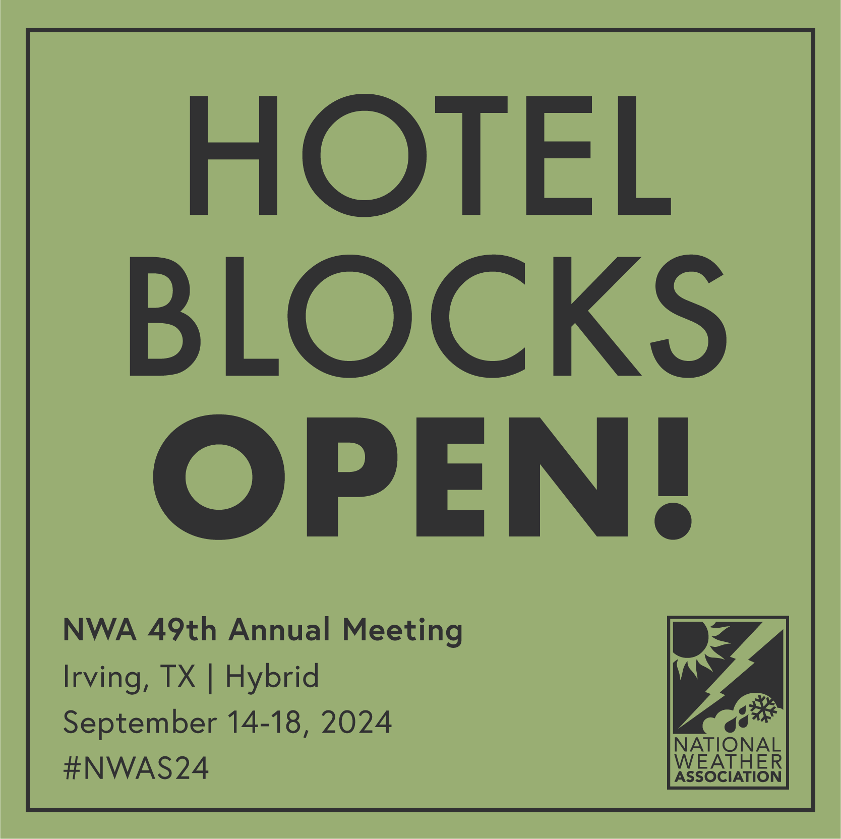
Hotel Room Blocks:
There are four hotels in downtown Huntsville that have blocks for the meeting. The Embassy Suites is attached to the Von Braun by a covered walkway. It is the main conference hotel. The other hotels where blocks are reserved are the SpringHill Suites, Homewood Suites and the new AC Hotel. Links to reserve rooms, and the prices, are located on this page.

Registration:
Attendee and exhibitor registration will open later in March. Prices for both will be posted soon.
Sponsor Opportunities:
Thanks to Baron for being our Title Sponsor for the meeting. The Weather Company, and IBM Business is a Platinum Sponsor, and Midland Radio is the Supporting Women in Meteorology Luncheon Sponsor. Sponsorships are still available. Contact the NWA Office for more information.
More information will be added to the 2019 Annual Meeting page as available.
Return to top
|
|
|
|